Tagging your images with GPS data
Geotagging of your images is done to store the location into the Exif metadata and to display the location on a map.
Introduction
I’m using geo logger for quite some time now to add a location to all my images. I started in 2008 with an i-blue 747 logger. The GPS data are part of the Exif data and can be managed or questioned in Lightroom.
There are different options to get the GPS data in first place and to combine them with your images. I did a little video on this:
Camera with built-in GPS
 There are a couple of cameras which allow to recieve GPS data with additonal accessories either via the hot shoe or the the remote control connector. These accessory modules are very pricy and have the disadvantage to block a connector on the camera.
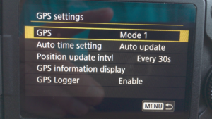
More comfortable and convinient are cameras with a built-in GPS in the camera body like the Canon 6D MK II. In this case there only a need to setup the desired mode and then GPS data are stored in the Exif header of the images.
Smartphone as GPS-Logger
 Since almost all smartphones have a built-in GPS modul hwat could be more practical to use this device for GPS logging. You need an app for continous track recording. with my Huawei Mate 10 Pro i already described this method in another blog post. I normally use the app GPS Logger, for this.
Here you can setup the intervall and the minmum distance between 2 location points. but this also depends on the accuracy needed in the track file.
This file is stored and can be used later on in Lightroom to apply the the GPS meta data to the images.
As a variant of this mehtod there is the possibility on some cameras for example my Lumix G81 to record the GPS data wita smartphone and tag the images in the camera with the help of an app via Wifi,
GPS Logger
There are also seperate GPS logger on the market like the already mentioned i-Blue 747 or the Holux M-241 which i use most of the time.
The data then are transfered to a pc or you can read the data from the logger with a smartphone. Because of the convenience i mainly use my smartphone for this and the app AndroidMTK which is configured to store the track-files from the logger to my personal cloud.
GPS Rollover
Logger like the Holux M-241 or other brands might have an issue which i occured in August during my vacation. Its the so called GPS_rollover bug which is caused by counting the weeks with a 10-bit counter only.
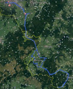
My GPS data from my vacation end of August. The track file with the positions was correct but all with a date in the 1980. Meanwhile Android MTK was updated and the problem is solved.
GPS and Lightroom
Lightroom offers a seperate field for the GPS metadata as a part of the Exif metadata and activates a bachward search for the locations to add city,country and so in. The map modul allows it to view the images and even add metadata from the map to the selected image.
To apply the GPS data to the images just select the images and load the track file.
Conclusion
From the examples you can see that there are different options to GPS tag your images, either manually or with a track file or right away in the camera. On the export you have to decide if you want the GPS data to be part of the image or if it would be better to hide the exact location. Deleting locataion data can be done in Lightroom.
ciao tuxoche


